Jul 25
/
Ilima Choy
Ipu Hoʻokele: The Navigatorʻs Gourd
Other Articles In This Series
Navigate the articles in this series.
-
Ipu Hoʻokele: The Navigatorʻs Gourd
-
The Hawaiian Star Compass
Hua ‘Ōlelo Hou
Here are some of the terms that you will find in this article and a definition based upon the context that they are used.
-
ipu hōkeo: a calabash used to store fishing items or food
-
la‘au: wood
-
ulu: breadfruit
-
koa: a tree native to Hawaiʻi, acacia koa
-
kōkō: net
-
‘alihi: a fine cord
-
pu‘u mana: additional knots in a net
-
‘ōpelu: makerel scad
-
aku: bonito
-
Kiopaʻa: Polaris
-
pū‘ulu hōkū: constellation
-
Newe: Southern Cross
-
kuamo'o: backbone
-
Ke Alaula a Kāne: Eastern sky
-
Ke Alanui Ma‘awe‘ula a Kanaloa: Western sky
-
kūkulu: pillar, direction
-
hikina: eastern horizon
-
komohana: western horizon
-
iluna: above, upward, northern
-
ilalo: below, downward, southern
-
hōkū ai ‘āina: guiding star
-
manu ‘iwa: frigate bird
“Mai ka hoʻokuʻi ā ka hālāwai.”
From the zenith to the horizon.
‘Ōlelo No‘eau #2059
The ipu ho‘okele wa‘a is a compass used by early Hawaiians to navigate across the great ocean. Some are made from an ipu hōkeo, others are made from the la‘au of ulu or koa. There were different size ipu ho‘okele wa‘a used for different types of travel. Large deep ipu ho‘okele were used to navigate near islands. Smaller shallower ipu ho‘okele wa‘a were used for open ocean travel or for rough seas.
It is said that the ipu ho‘okele wa‘a had a kōkō that was used like a grid at the top of the ipu. An ‘alihi is threaded through the kōkō below the base of the rim to secure it. Pu‘u mana are used to mark various stars. The ipu is also filled with water to reflect the stars used to guide one’s path.
The ipu ho‘okele wa‘a were still used in the 1880’s by skilled fishermen who would travel to Kuai-he-lani. Kuai-he-lani is located in what is now known as the marine sanctuary Papahanaumoku, or the Northwest Hawaiian Islands. Fishermen would travel there during the summer months to fish for ‘ōpelu and aku.
There are four holes or notches at the rim of the ipu. These are used to calibrate the compass by aligning the holes to known directions. There are two holes that lined up with Kiopa‘a and the star at the bottom of the pū‘ulu hōkū of Newe. A line is drawn at the bottom of the ipu connecting these two holes. This line marks the meridian that divides the ipu in half known as the kuamo'o. The half to the east is called Ke Alaula a Kāne and the half on the west is called Ke Alanui Ma‘awe‘ula a Kanaloa.
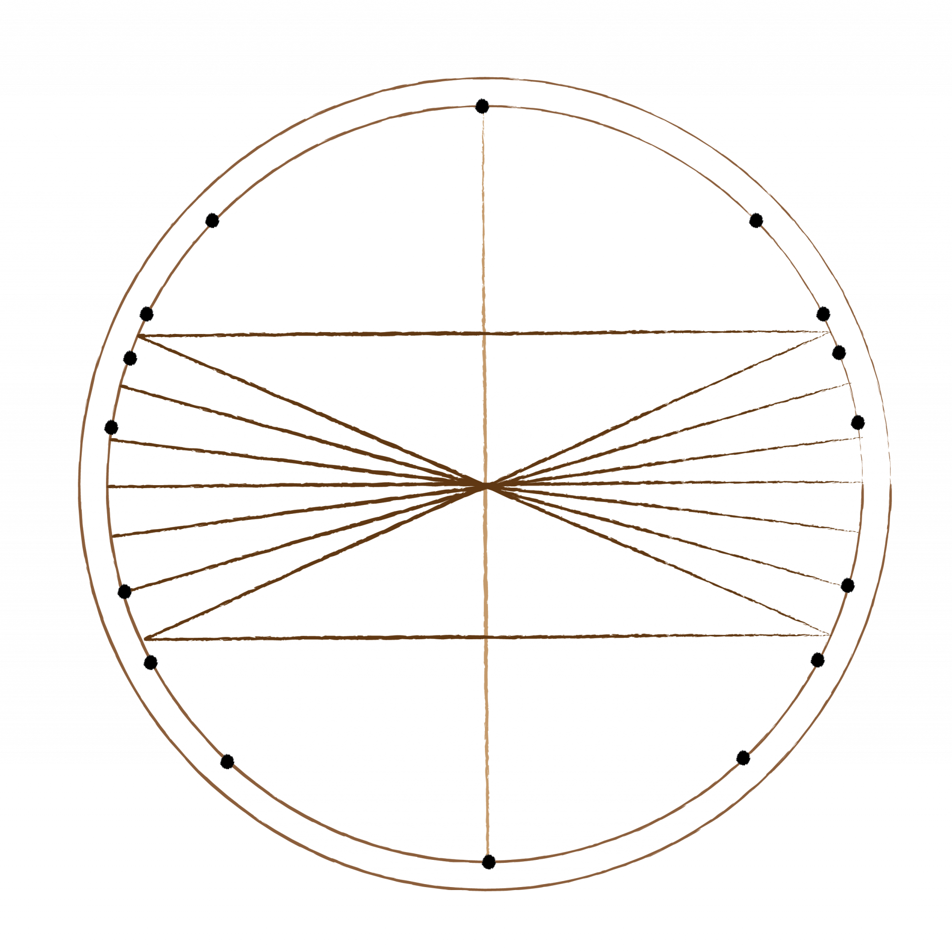
The holes that mark the kūkulu of hikina and komohana were aligned with various stars that were rising or setting at the time. A line is drawn at the bottom of the ipu connecting these two holes marks the celestial equator. This is called Ke Alaula a Ke Kuukuu (The Path of the Spider) or Ke Ala i ka Piko o Wākea (The Path to the Center of Wākea).
Two other lines were drawn in at the bottom of the ipu, iluna and ilalo of Ke Ala i ka Piko o Wākea. The line iluna is called Ke Alanui Polohiwa a Kāne, it marked the northern most reach of Ka Lā. The line ilalo is called Ke Alanui Polohiwa a Kanaloa, it marked the southern most reach of Ka Lā.
Two other lines were drawn in at the bottom of the ipu, iluna and ilalo of Ke Ala i ka Piko o Wākea. The line iluna is called Ke Alanui Polohiwa a Kāne, it marked the northern most reach of Ka Lā. The line ilalo is called Ke Alanui Polohiwa a Kanaloa, it marked the southern most reach of Ka Lā.
The stars that are observed within these two paths were called hōkū ai ‘āina, and they were followed to travel to known lands. There are nine principle stars that are usually used to guide early voyagers, just like manu ‘iwa.
Activities
Building an Ipu Hoʻokele
Watch the video below and build a model of an ipu hoʻokele.
References
Kamakau, S.M., (1865, August 5). No ke Ao Hoku. Ka Nupepa Kuokoa. https://www.papakilodatabase.com/pdnupepa/?a=d&d=KNK18650805-01.2.22&e=-------en-20--1--txt-txIN%7ctxNU%7ctxTR--------
Johnson, R. K., & Mahelona, J. K. (1975). Nā Inoa Hōkū. In T. Kelsey, Appendix: Navigation Gourd Notes (pp. 142-153). Honolulu, Hawaii: Topgallant Publishing Company, LTD.
You must be signed in with a paid membership to view this content.
Please sign into your membership account to access this content.
If you are not a member, check out our hālau memberships and become a member today.
If you are not a member, check out our hālau memberships and become a member today.
Become a Kāiaulu Member
Be Engaged...Be Inspired
He Ui?
Have a question about Ē
Ala! Online Learning Academy?
Thank you!
ho'ohala
- offense
- fail to do
Kumu Informational Sessions
Wednesday, September 7, 2022
Session 1: 10:30 am - 11:30 am
Session 2: 5:00 pm - 6:00 pm
Session 1: 10:30 am - 11:30 am
Session 2: 5:00 pm - 6:00 pm
Choose the session that works best for you and confirm your seat.
pono
- upright
- moral qualities
- excellence
- beneficial
hālau
meeting house used for instruction and other activities
ho'olaha
- to broadcast
- advertise
- distribute
haumana (n.)
Student, pupil, apprentice, recruit, disciple.
mākāhā
- Sluice gate, as of a fish pond;
- Entrance to or egress from an enclosure
waʻa lāʻī
- a toy canoe made from a tī leaf
honu
green sea turtle
hoʻopili mai
do the activity together
hua ʻōlelo
- term or word
wahine kanaka ʻōiwi
native daughter
maka
- eye
- point, but, center of flower
- beloved one
kilokilo
- a skill of observation and critical thinking
Write your awesome label here.
ho'olaha
- to prepare
mākaukau
- ready
- able
- competent
koʻolau
- According to S.M. Kamakau, in his article "Ka Mo'olelo Hawai'i" (4 Nov 1869), "O Kuanalio kekahi inoa i kapaia aku ai..."
- According to P & E,: northern heavens and its stars.
kona
- direction of south
- liolio-i-wawau or Southern Sky
ipu hoʻokele waʻa
- navigator's gourd
ipu hōkeo
- a calabash used to store things in
laʻau
- wood
ulu
- breadfruit
koa
- acacia
kōkō
- a net used to carry items
ʻalaihi
- a string that is reddish in color
puʻu mana
- a branching knot
ʻōpelu
- mackerel scad
aku
- bonito
hōkū ai ʻāina
- guiding star for land or islands
Available in Foreign Office & Executive Chronological File, 1790 – 1849 1843 Nov 16, 23, 25, 28.
haʻawina
- lesson
Created with